Between 1893 and 1900, all surviving horsecar lines and the West End steam line were electrified. (A few marginal lines had been abandoned by 1900.) The most obvious trackage change was that turntables were no longer needed. New Orleans had gone in for single-ended bob tail horsecars in a big way, but electric streetcars in the Crescent City were always double-ended. Another major change, effected in January 1896, was that the electrified NO&C lines entered Canal Street at Baronne and operated in to the loop at the foot of Canal on the C&CSRR outer tracks. This posed a problem of track gauge, since for the first time, standard gauge lines were to run on Canal Street. So when it electrified its lines, the C&CSRR converted its entire system to standard gauge! Even so, it was necessary for the outer tracks to be dual gauge between Rampart and St. Charles on the uptown side, and between Royal and Dauphine on the downtown side, to accommodate the cars of other companies. Fortunately, the six-inch difference in gauge was sufficient to permit wheel clearances on three-rail dual gauge track.
| Picture 69. | |
|
|
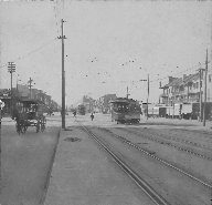
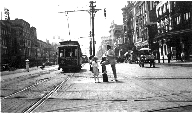
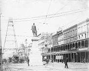
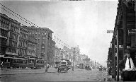
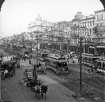
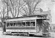
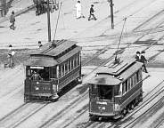
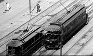
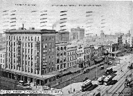
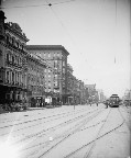
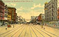
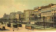
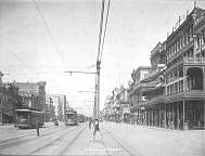
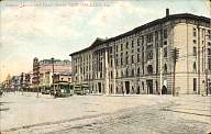
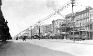
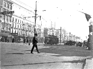
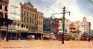
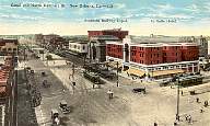
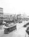
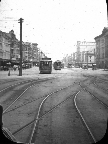
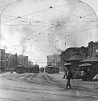
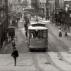
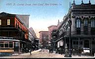
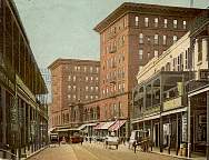
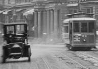
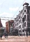
This is one side of a stereoview of Canal St. looking west. Assuming the usual New Orleans convention, that north is downtown from Canal St., this means that the view looks out toward the lake, and is almost true compass north. The caption on the card says it looks from Burgundy Street, but it must have been taken with what today we would call a telephoto lens, because the intersection in view is Canal and Rampart Streets. The closest streetcar, car 143, is labelled Magazine, which dates the photo to the brief period of October 13 to December 29, 1902, when the Magazine line was married to the Dauphine line. Car 143 was one of the group 116-165 ordered from Brill in April 1894. Further in the distance we see another car on Canal Street; it could be on the Esplanade Belt or the Villere line. In the distance we can see a plume of smoke from a steam engine; if this is on the streetcar tracks, it is not pulling a passenger train, as the West End line began using electric power in place of steam power in 1898. One might speculate that it is a leftover West End steam dummy pulling some kind of work train. Note the dual gauge on the outer track in the foreground. The outer track on the far side of Rampart is standard gauge for the North Claiborne line. The wide gauge track turning in from Rampart was used by the Dryades line. My profound thanks to Morris Hill for this analysis. George Parradee |
| Pictures 70, 71, and 72. | |
|
|
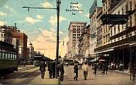
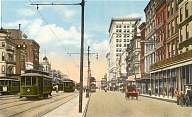
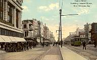
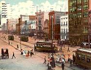
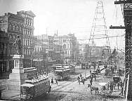
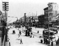
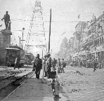
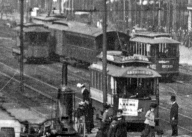
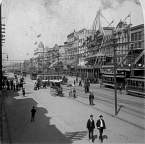
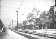
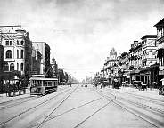
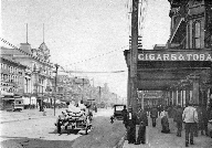
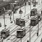
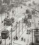
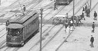
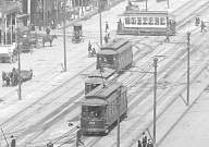
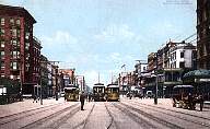
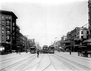
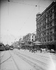
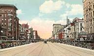
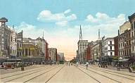
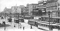
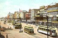
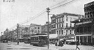
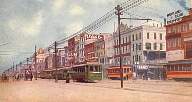
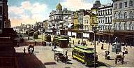
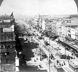
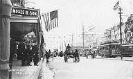
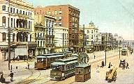
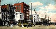
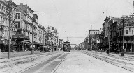
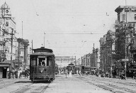
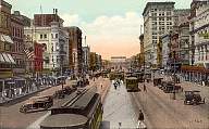
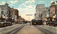
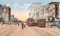
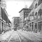
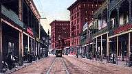
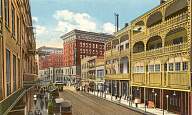
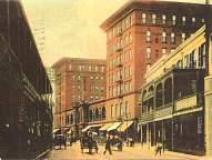
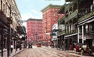
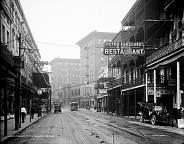
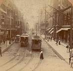
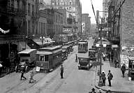
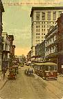
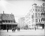
In the top picture, the photographer is standing at Royal Street looking out toward Bourbon. The middle picture was taken from about the same place. In both, we see mostly single truck cars, with the distinctive tower building at Carondelet Street at the left edge, of each picture. On the right in the middle picture, we see signs for Grunwald Pianos and for Marks Isaacs Co. In the bottom picture, we are looking in toward the river from a mid-block spot next to Maison Blanche, between Dauphine St., behind the photographer, and Bourbon St., ahead, with downtown to his left. In the next block, we can see a large vertical sign for a Katz & Besthoff, the long-time New Orleans drug store chain. The dash sign on the closest car, approaching on the lakebound inner track, can be seen: Pay Conductor on Entering. In the foreground in all three pictures, the double right rail of the three-rail double-gauge outer lakebound track can be seen, with deteriorated paving between the rails in the bottom picture. F. M. Kirby & Co. (top), C. T. American Art (middle), Lipsher Specialty Co. (bottom) |
|
|
|
|
|
|
| Picture 73. | |
|
|
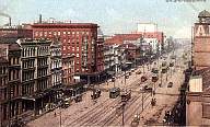
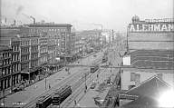
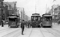
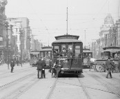
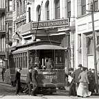
Single truck, standard gauge car 258 is heading in to the river on the outer track at Baronne Street. The dash signs read Pay conductor on entering and Baseball New Orleans vs Atlanta Pelican Park. The St. Charles/Tulane Belt cars passed right by Pelican Park, at Tulane and S. Carrollton, which suggests that this car was on one of the Belt lines. Unfortunately, the route sign cannot be read to confirm this. New Orleans Ry. & Light Co. ordered standard gauge cars 255-259 from McGuire-Cummings in 1908. They were part of the last order of Ford Bacon & Davis (FB&D) cars in New Orleans. This picture gives us another good look at the double right rail of the dual gauge track. Note the ornate scroll work on some of the poles supporting the overhead system and the street lights. |
| Picture 74. | |
|
|
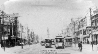
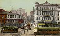
A riverward view of Canal Street from the Baronne/Dauphine intersection, postmarked 1906. The single-truck car crossing in the middle of the picture is on the St. Charles line, turning left from the outer lakebound track to enter Baronne Street for the trip uptown to Carrollton. |
| Picture 75. | |
|
|
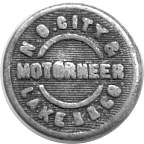
Beginning in 1892, the New Orleans Traction Co. operated the lines of the old New Orleans City RR, known since 1883 as the New Orleans City and Lake RR, and of the Crescent City RR. In 1899, these two companies merged into a second New Orleans City RR. Uniform buttons of this type are known marked New Orleans City & Lake R. R., Crescent City R. R., and New Orleans City R. R., with job titles Conductor and the unusual variation Motorneer. Presumably, the Motorneer buttons came into use in the middle 1890s, when these lines began to electrify. This very worn button must have been appropriate for no more than about four years, but it appears to have remained in use considerably longer. |
During this period, the massive base of the Clay statue was reduced, and in 1900 the statue was moved to Lafayette Square, a few blocks uptown on St. Charles Street. This facilitated changes in those lines which had terminated there in horsecar days. The six tracks on the lake side of the statue were reduced, initially to five, and later to four. The wide gauge lines of the NOCRR (excluding the West End line) now operated through on the inner tracks; those which had formerly terminated at the turntable on the lake side of the statue were extended in to a new double track stub end terminal at the Liberty Monument, and those lines which formerly used the turntable on the river side of the statue were extended out two blocks past Rampart Street to another new double track stub terminal located in N. Franklin Street (now Crozat Street). The ORR lines, which had formerly circled the statue, now operated riverbound on the outer track, then crossed over the inner track to a fifth, center track, which they used as a stub end terminal between St. Charles/Royal and Camp/Chartres. After changing ends, these cars crossed over the lakebound inner track to the outer track to begin their return trips.
| Pictures 76, 76.1, and 76.2. | |
 |
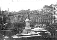
This badly damaged picture (top) from the Detroit Publishing
Co. archives is one of the few to show the Clay statue in early electric days,
after the massive base was severely cut back. We are looking
out toward the lake. The left track in this view is the outer riverbound
track, and the track at the right side of the picture is the terminus for
the Orleans RR lines.
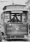
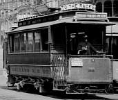
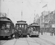
The second and third pictures are details from the first. The second picture features Tulane Belt car 222, riverbound on the outer track. The route sign is visible hanging from the platform roof, and also in the front glass of the clerestory. Car 222 was an FB&D car, one of the group of 70 cars numbered 160-229 built by the American Car Co. of St. Louis in 1899 for the New Orleans & Carrollton. Note the wire mesh fender, a type not clearly seen on many photographs. The third picture shows car number 10 of the Orleans R. R. Co., operating on the Broad line; the route sign above the platform roof says, BROAD VIA ST. PETER, and appears to be an early form of a roll sign. A sign hanging over the front dash adds, TO CANAL STREET. More signs arching across the car roof proclaim, TO FAIR GROUNDS and TO THE RACES. We are seeing the car just as it pulls up to its terminal on the center track. Car 10 was one of the first group of electric cars for the Orleans R. R., cars 1-20, built in 1895 by the Brill Co. of Philadelphia. We have a view of another, slightly different wire mesh fender, with a slot from which a coupler peeks out. The picture can be dated quite closely. The light tower at the Carondelet/Bourbon intersection was removed in 1897. Tulane Belt car 222 was built in 1899. The Tulane and St. Charles Belts were started in 1900. And the Clay statue was removed from Canal Street about 1900. Library of Congress, Prints and Photographs Division, Detroit Publishing Company Collection |
 |
|
 |
|
| Picture 76.3. | |
 |
This view is so similar to the previous one (Picture 76), though it is not the same picture, that they were probably taken by the same photographer just minutes apart. We see a pair of single truck streetcars on the inner tracks pass next to the Clay statue. We can even make out the details of the tracks; for example, at the right, we can see the crossover from the center track to the right-hand (lakebound) outer track. In the distance just to the right of center, we see the dome of the old Maison Blanche department store. collection of Carol Eads |
| Picture 76.5. | |
 |
The Clay statue and the busy passage of electric streetcars, some time in the later 1890s. The view looks toward the uptown side of Canal Street, toward the building at the corner of St. Charles Street. The closest streetcar is on the lakebound outer track. Unfortunately, not much detail of the streetcars can be discerned. |
| Picture 76.7. | |
 |
Brill car 228 is approaching the photographer on the inner riverbound track. This was one of the cars ordered by New Orleans Traction Co. in January 1895, and probably delivered later that year. The light tower at the Carondelet/Bourbon intersection dates the picture to some time before 1897. At the center right, we have a good view of the crossovers used by the Orleans RR lines to enter and leave their center-track terminus. The big tower sits astride the intersection of Carondelet and Bourbon with Canal Street. The dome of the old Maison Blanche building can be seen beyond and right of the tower. |
| Picture 77. | |
 |
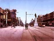
This picture of early electrified Canal Street has some unusual elements. We are looking out from the Clay statue at St. Charles/Royal to the tower at Carondelet/Bourbon. The presence of the tower dates the picture not later than 1897. The stepped base of the statue is gone. We can see streetcars on all five tracks between the two cross streets. Later, there was a gap in the center track here, but at this time, we can see three streetcars on the center track between the Clay statue and the tower. Of course, the center track could not cross the St. Charles/Royal intersection, because of the statue. Some lines terminated here in the period from 1895 to about 1900. It is not known at what date the center track was removed between Baronne/Dauphine and St. Charles/Royal. After that time, the center track out from Baronne/Dauphine was used only by West End trains, none of which are seen in this picture. A. Wittemann, Picturesque New Orleans, 1898 |
| Picture 77.2. | |
 |
This photo looks toward the river from the Carondelet/Bourbon intersection. It dates after the removal of the Clay statue from the next cross street, St. Charles/Royal, about 1900, and before the enclosure of all streetcar platforms in 1904. Unfortunately, it is not possible to make out the route signs on the cars, even those nearest the camera. There are at least seven streetcars in this one block of Canal Street. We see widespread use of umbrellas by the ladies avoiding the hot sun. There is a man standing on the neutral ground, in the middle where the fifth track would be, next to a small stand which seems to include a white umbrella. He is standing next to a track switch. One can guess that he is there to set the switch as needed as the outbound streetcars come up to that point. John N. Teunisson |
| Pictures 77.4, 77.5, and 77.6. | |
 |
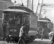
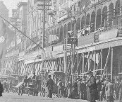
This view looks out from the corner of Canal and Royal Streets. The second and third pictures are details from the first. The nearest streetcar, 89, is on the Canal line; just ahead of it is a sister car, number 9-something, on the Villere line. Note the conductor on the rear platform of car 89, with his hand raised to his signal cord. Villere was started October 15, 1895, and initially terminated on the center track on the lake side of the Henry Clay statue. The lighting tower at Carondelet dates the photo to no later than 1897. It is winter, judging by the people's clothing. In 1898, Villere was changed to operate to the loop at the foot of Canal. (In 1926, this line would evolve into the Gentilly line.) These two cars were part of a New Orleans Traction Co. order from Brill in February 1894, cars 66-115. The roadway to our right is paved, although one might doubt it, with the pile of dirt (or something) in the foreground. In the nearest track, to our left, we see a plank walkway to provide traction for the mules; the space between the rails appears to be unpaved dirt. The (North) Claiborne and Tulane lines, which used this track, were not electrified until 1896. However, conversion is in progress, as there is a trolley wire above this track. At our right center, note the series of braces set at an angle to support the balconies. There is a man working at the top of a ladder, which he has apparently climbed from street level to the balcony. Possibly the balconies are under some kind of construction or renovation, or perhaps they are being reinforced to take the weight of many spectators during Mardi Gras parades. |
 |
|
 |
|
| Picture 78. | |
 |
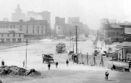
This picture shows Canal Street in the process of converting from horse/mule and steam power to electric power. It comes from a glass slide that itself appears to have been made from one side of a stereo view. It is clearly dated June 1896. Note the West End train on the center (fifth) track at the left foreground of the picture. It is being powered by a steam dummy; it would be another two years before a group of double truck electric cars would arrive to replace the steam power. There is a switch in the track ahead of the steam dummy; it will probably drop its train then take the switch and run around the train to recouple at the other end, reversing direction for its next trip. In the center foreground, electric car 32 marked Dryades St. is following a horsecar on the outer riverbound track. Car 32 was one of the original electric cars, numbers 1-40, built in 1895 by the Pullman Co. for the St. Charles Street RR. The rest of the many cars in the picture also seem to be electric cars. We see the electric tower astride the intersection of the Canal Street neutral ground with Bourbon and Carondelet Streets. In the distance, Henry Clay's statue seems almost to float on top of its stepless base at the Royal/St. Charles intersection. The big banner over the neutral ground advertises: Grand Concert / Audubon Park Night / Matinee Concerts 2 to 4 / Sunday Wednesday Thursday. Wm. F. Booth |
| Picture 79. | |
 |
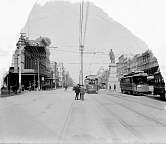
This picture is from some time between 1897 and 1900. The Clay statue can be seen in the center, and the distinctive tower of the building at the corner of Canal and Carondelet at the left, so the view is toward the lake from a point between Camp/Chartres (at the photographer's back) and St. Charles/Royal (ahead, where the statue is located). We can see streetcars on four of the five tracks at this point, all except the left-hand (riverbound) outer track. On the center track, we see Orleans RR car 199 preparing to begin its outbound trip. This car appears to be a New Orleans Traction Co. car, one of the 1894 Brills. At our right, on the lakebound outer track, a standard gauge FB&D car ornately marked for the N. O. & C. R. R. Co. shows a mesh fender, and a route sign (unfortunately unreadable) hanging from the platform hood; it would have been operating on St. Charles, Jackson, or the original Napoleon line. |
| Picture 79.5. | |
 |
A typical scene somewhere on Canal Street. The double truck car at the far left is one of the Brill semiconvertibles, identifiable by its window configuration, possibly operating on the Coliseum line. The date is probably some time between 1906 (when the Brill semis were built) and 1910. All the other cars in this view are various single truck cars. Unfortunately, none of the car numbers or route signs are readable. There is a streetcar man at the far left of the photo who appears to be operating a track switch. Note the wagon in the center of the photo, with an umbrella to give the driver some shade from the hot New Orleans sun. |
| Pictures 80, 80.1, 80.2, 81, 82, and 82.5. | |
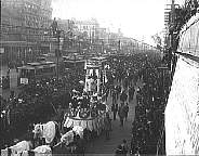 |
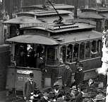
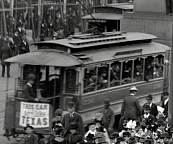
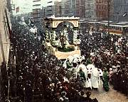
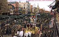
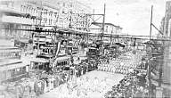
The Krewe of Rex parades for Mardi Gras. The top picture was taken some time in the middle to late 1890s. Note the Henry Clay statue with its reduced base in the middle of the St. Charles/Royal Street intersection. This view is facing out, toward the lake. The next two pictures are details from the first, clipped from an enhanced image posted on Shorpy.com. Car 92 is working the Peters Ave. line, as indicated by the sign on the dash. The roof sign reads, IC/L&N DEPOTS. This car was part of a big 1894 order from the Brill Co. for cars 66-115. Note the notched window sash. The other detail view highlights car 236, which was part of an 1893 order from Brill that included cars 51-65 and 230-239. (Why ten of these cars were numbered in the 200s is a curious little mystery.) Again, we see seven notched windows. The fourth picture is dated 1901. Its location is not clear. Note that there is no sign of the Henry Clay statue, which by then had been moved to Lafayette Square. The fifth picture is from a card that is postmarked 1912. The closest intersection is Carondelet and Bourbon Streets, looking out. The bottom picture, dated April 30, 1912, shows a U. S. Navy unit passing. A good deal of detail can be made out in this picture, but unfortunately, the only car number that can be read is for one Palace car, number 0126, about in the middle of the picture, inbound toward the river. Across the neutral ground from 0126 is an FB&D car with the markings of the New Orleans & Carrollton RR, on the outbound outer track. Most of the lines crossing the bottom picture left-to-right are the overhead trolley wire and its supporting wires. There is actually a close-up view of some of the hardware of the overhead wire system. In later years, streetcars were turned back during the parades, and the crowds were allowed to mill around on the empty Canal Street neutral ground. Library of Congress, Prints and Photographs Division, Detroit Publishing Company Collection (top), Detroit Photographic Co. (fourth); detail views from Shorpy.com |
 |
|
 |
|
 |
|
 |
|
 |
|
| Pictures 83 through 87, 87.5, and 88. | |
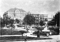 |
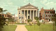
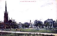
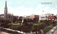
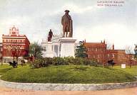
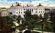
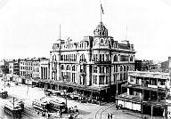
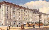
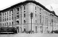
Lafayette Square, between St. Charles and Camp Streets, the second oldest Public Square in New Orleans (after Jackson Square). We see the park after the 1901 removal of the Henry Clay statue from the corner of Canal and St. Charles/Royal Streets. The Clay statue is in the center of the park, which makes it the farther one in the top two pictures. He is posed facing the old City Hall. The John McDonogh statue also faces St. Charles Street and City Hall; its significance is left as an exercise for the reader. The top two pictures are looking across the park from in front of City Hall. The domed building in the background, on Camp Street, is the public library. The City Hall itself, seen face on in the third picture and to the right in the fourth and fifth pictures, is across St. Charles Street from the park. The building to our left of City Hall in the third picture is under construction. The beautifully spired church is the First Presbyterian, built in 1854, and destroyed in the hurricane of September 1915; parts of it survive in the present First Presbyterian Church on S. Claiborne Ave. Note how the trees have grown from the fourth picture to the fifth. The sixth picture faces City Hall from Camp Street, looking all the way across the park. The closest statue is of Benjamin Franklin. In 1873, Franklin had been set in the center of the park, but was moved to the Camp Street side when the Henry Clay statue was moved into the park, taking the center spot. By 1909, the Franklin statue had deteriorated to the point that it was moved to an indoor spot in the New Orleans Public Library. Eventually, it was set up in the corridor of the Benjamin Franklin High School. The bottom picture, postmarked 1922, shows the then-new Post Office, on the other side of the park, which replaced the public library building on Camp Street. Albertype (top), Raphael Tuck & Sons (second), Adolph Selige (third), New Orleans News Co. (fourth), J. Scordill (fifth), C. B. Mason (sixth), C. T. American Art (bottom) |
 |
|
 |
|
 |
|
 |
|
 |
|
 |
|
| Picture 89. | |
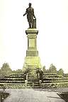 |
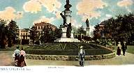
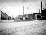
The Henry Clay statue after its removal to Lafayette Square, and before the trees in that park grew up around it. Geo. Lipsher |
The original six tracks between Magazine/Decatur and Peters were rearranged into five when the lines using these tracks were electrified. In place of the old turntables at Camp/Chartres and Magazine/Decatur, these lines ran lakebound on the inner track from Peters, switching to the center track to terminate at Camp/Chartres. After changing ends, these cars returned to Peters on the inner riverbound track. There were several crossovers in these two blocks to facilitate these movements.
About the same time, two new lines were established, Henry Clay and Peters Avenue*, which used the inner tracks to the foot of Canal, then turned into Wells Street to terminate in a double track scissors crossover. Presumably to avoid conflict with the other inner-track lines, there were six tracks here: from outer to inner, there was first a standard gauge pair leading to the loop, then the pair of tracks leading to the Wells Street terminus, then the innermost pair for the NOCRR lines double track stub end on Canal itself. About 1900, this arrangement was further expanded to eight tracks, when two layover tracks were added to the outer track on the downtown side.
| Picture 90. | |
 |
The intersection of Canal and Dauphine St., 1898, showing early electric cars on all five tracks. The car at the left edge of the picture, on the center track, has an arch roof, identifying it as one of the locally built double truck trailers used on the West End line. The building in the center of the picture is the original building of Maison Blanche (literally, White House), New Orleans' fine old department store. |
| Pictures 90.5 and 90.6. | |
 |
This stereo view is taken at about the same angle as the previous picture, looking toward Maison Blanche, but from a point near the corner of Carondelet/Bourbon and Canal. The nearest car, car 184, is marked N. O. & C. R. R. CO. (New Orleans and Carrollton RR Co.); it is on the outer riverbound track. It was part of an order of 70 Ford Bacon & Davis (FB&D) cars, numbers 160-229, built by American Car Co. in 1899. Across from it, on the outer lakebound track, is another car from the same order, with the same markings. We can see the double right rail on the dual-gauge track in front of car 184. Behind car 184, on the inner riverbound track, is a Brill car number 23-something, one of the group 230-239 ordered as part of the first order of cars from Brill in 1893 for the 1895 electrification of the New Orleans City & Lake RR lines. It is still riding on its original double trucks. At the far right we see another Brill car, marked for the N. O. C. (New Orleans City) & Lake RR. This one has lost its original double trucks in favor of a single truck. Following car 184 on the same track is a Pullman car with a sign for the opera Lakmé. It appears to be on the Dryades Line of the St. Charles Street RR, which makes this car one of the 40 cars ordered from Pullman by that company in 1895, numbers 1-40. There is no center track in the block to our right (between Carondelet/Bourbon and St. Charles/Royal Streets). But in the block to our left, we can see a West End train on the center track, and some crossovers are visible which were presumably used by the West End motor car to run around its trailers in preparation for its return trip. The West End trailers are rarely seen in pictures from this era. The closer one, with a primitive arch roof, is a passenger trailer, probably one of the Coleman trailers built in New Orleans, seen in its original configuration. Behind it (to our left) is a railroad-roof trailer which appears to be the baggage car. The only other known pictures of the baggage car are found on page 170 of Hennick & Charlton's book The Streetcars of New Orleans. A motor car can be seen at the head of the train, apparently ready to begin its run out to West End. Just this side of the Coleman trailer is another Brill car, number 235 or 236, on the inner lakebound track; we cannot see its truck(s). The second picture is a blown-up detail of the West End train, with the Brill 235 or 236 near it, and the Pullman car in the foreground. All the streetcars in this picture, except for the cars in the West End train and at least one of the Brill cars, are single truck cars. Note the horse (or mule) drawn wagons moving merchandise along Canal Street, operating in both directions on each side of the neutral ground. The picture probably dates from the very early twentieth century, before the 1904 conversion of open car platforms to closed. H. G. White |
 |
|
| Picture 91. | |
 |
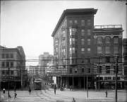
This picture looks toward the old Maison Blanche building from a spot between Camp and St. Charles Streets, at about the same angle as the two previous pictures. The open platforms on the streetcars tell us that the date is earlier than 1904. A Clio or Carondelet car is crossing Canal from Royal to St. Charles. At the right edge of the picture is a car on the inner lakebound track, and just in front of it (to our left) we see a car marked N. O. & C. R. R. on the outer lakebound track. In the right foreground, we can see the crossover that takes the Orleans RR cars from the riverbound outer track, across the inner track, to their stub-end terminal on the center track. Isn't it wonderful that citizens are able to stroll down the roadway without fear for their lives! R. R. Whiting (Library of Congress, Prints and Photographs Division) |
| Picture 91.5. | |
 |
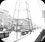
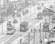
On February 11, 1899, a severe cold front hit the entire east coast of the United States, including the south. On February 12, snow began falling in Florida, and progressed west to engulf New Orleans. The result in New Orleans was a true blizzard, with 3.8 inches of snow, high winds, and temperatures falling from the 20s into the teens. On the morning of the 13th, temperatures were below 7°F. This picture of the snow on Canal Street was taken on the 13th. We are looking away from the river toward the downtown side of Canal from a point near Carondelet Street, with the old Maison Blanche building (the building with the dome and flagpole) very prominent. This snowfall was smaller than the one three years previous (see Pictures 13 through 14), but the overall blizzard conditions were worse in 1899. The closest streetcar is number 224, one of the group 216-229 ordered by New Orleans Traction in 1895 from Brill, having 8 arched windows. The car at the left is hard to identify, but appears to be a Pullman in the 320-336 order by the Crescent City RR in 1896, sometimes known as Annunciation cars. The other two streetcars visible in the picture are unidentified. F. D. Edmunds |
| Picture 92. | |
 |
A sister car to car 184 seen in Picture 90.5, car 188 is seen somewhere along the New Orleans & Carrollton St. Charles-Tulane Belt line, probably on St. Charles Avenue. These cars were part of a group of 70 single truck cars, numbers 160-229, built by the American Car Co. for the New Orleans & Carrollton in 1899. The cars were designed by the engineering firm Ford & Bacon, later Ford, Bacon & Davis (FB&D). This firm designed the electrification and improvements to several New Orleans streetcar companies, beginning in 1894 with the Orleans RR, the Canal & Claiborne RR, and then the New Orleans & Carrollton. The work included the specification of an improved electric streetcar, a design which was so successful that it was adopted by the other street railroads in New Orleans, of both track gauges. Eventually 217 of them ran in the city. Perhaps the most distinctive feature of the FB&D car type is the wide clerestory roof, which is even more obvious in Picture 94. This car is also seen in Picture 109, later in its life, after closed vestibules had been added in 1904. New Orleans & Carrollton R.R., Light & Power Co. |
| Picture 93. | |
 |
An unusually quiet moment on Canal Street around 1900, looking out toward the Carondelet/Bourbon intersection. The lone streetcar (which is, unfortunately, heavily retouched in this picture) is displaying a Jackson route sign in the front clerestory window. It is on the outer riverbound track, heading for the loop terminus at the foot of Canal Street. Note the crossover between the inner tracks and the lack of a center track at this point. There is a little booth, perhaps a starter's shelter or a ticket booth, to the right at Bourbon Street. It can be seen in other pictures also: for example, Pictures 119 and 123. Frank S. Thayer |
| Picture 94. | |
 |
This view looks toward the river, with the University Place intersection in the right foreground. The downtown side of Canal Street is seen on the left and in the distance. The distinctive tower at the left is the old Maison Blanche department store building; this dates the picture to the first few years of the 1900s. The streetcar at the left edge of the picture is a single truck Ford Bacon & Davis (FB&D) car, identifiable by its very wide clerestory roof and rectangular windows. The mule-drawn wagon, the very early automobile, and the bystanders looking at the photographer complete the picture. Albertype |
| Picture 94.5. | |
 |
Here is an early 1900s view of Canal Street from the St. Charles street intersection, looking toward the river. The Custom House can be seen in the distance on the far side of Canal. The track curve in the foreground carried cars of the Coliseum line into the riverbound inner track, crossing the outer track with its double-gauge right rail. Ahead can be seen the crossover that carried Orleans RR cars from the outer track to their center track terminus. At left is a “Palace” car on the Canal Belt line, showing an unusual route sign mounted on the side of the car. Behind it on the lakebound inner track is single truck FB&D car 348. This was one of the 30 wide gauge cars, numbers 325-354, bought from McGuire-Cummings in 1908 (along with 5 standard gauge cars), the last order of FB&D cars for New Orleans. (Cars 350-354 were later renumbered 320-324.) The picture features long lines of streetcars on Canal Street, but none of the rest are identifiable. The big sign over Canal Street reads, “New Orleans / The Gateway to / Panama Canal”. E. B. Thomson photograph |
| Pictures 95 through 95.3. | |
 |
The top picture is from a picture postcard showing
an elevated view out toward the lake. The first intersection
is Camp and Chartres Streets. A car on the French Market, Levee and
Barracks, S. Peters, or Tchoupitoulas line is on the center track changing
ends at that intersection. In the next block, a car on one of the
Orleans RR lines (Bayou St. John, Broad, or City Park) is maneuvering from
the outer riverbound track to the center track, where it will change ends
for its return trip. The date is sometime between 1902 and 1904.
The other three pictures are high-resolution details from the original, as posted to the web by Shorpy.com. The first of these shows FB&D car 142 on the riverbound outer track. The route sign in the clerestory glass says Claiborne Avenue. There is another route sign hanging from the lip of the platform roof, but it is not readable. Car 142 is a standard gauge single truck car, one of the group built in 1896 by American Car Co. as numbers 25-49 for the Canal & Claiborne RR before its absorption into the N. O. & Carrollton, where the group was renumbered in 1899 to be 125-149. On the center track next to car 142 is car 74 of the N. O. City RR, showing a Levee & Bcks (Barracks) route sign on its dash. This car was part of the 1894 order from the Brill Co., order number 5777, which produced 7-window cars 66-115 for the electrification of the NOCRR lines. It is seen at its terminal, riding on its original double trucks. The second detail view shows the block between Camp and St. Charles Streets. On our left at the front is car 160 (or possibly 150) on the riverbound inner track. The route sign on the dash is unreadable. This car was part of the Brill order number 5779 which produced in 1894 cars 116-165. It is another 7-window car, still on its original double trucks. In the center front, we see a car apparently numbered 275 (though it is not very clear), on the inner riverbound track. Again there is a route sign, unreadable, this time on the corner of the dash panel. Car 275 was part of order number 92 from St. Louis Car Co. that produced cars 260-277 in 1900. Seen just behind car 275 is car 61 of the Orleans RR, in the process of switching from the riverbound outer track to its terminal on the center track. It carries its route sign above the lip of the platform roof; though unreadable, it must be for the Bayou St. John, Broad, or City Park line. Car 61 is a single truck FB&D car built by St. Louis Car Co. in 1902, order number 245, the high-numbered car of the group 50-61. Leading car 275 are a Palace car and a smaller car, but few details can be made out. However, we can see that the Palace car has a vertical handbrake wheel, so we know it must be equipped with air brakes, the first New Orleans cars to have them. Another Palace car, riverbound on the inner track, is waiting for pedestrians and car 61 to move out of its path. We can see ten more streetcars in the third detail picture. At the lower left corner, there is yet another Palace car on the inner lakebound track. There is a cluster of three streetcars just out from that Palace car. On the outer riverbound track, we can see a St. Charles Street RR Pullman car, but we cannot read its number or route signs. Next to it, on the inner riverbound track, is a rare view of a Morris car, one of the group originally numbered 046-057, built 1902-03 in New Orleans, designed by Edmund J. Morris of N. O. City Railway. Although we cannot read its number, it is identifiable by its length, its double trolley poles (at this date, even the long Palace cars had only a single trolley pole), and the doubled car number on the front dash, necessitated by the train door in the middle of the dash. Behind the Morris car is another small car, perhaps another of the 1894 Brills. The other six cars in this view are too far away to be identifiable. There is a line of three on the outer lakebound track at our right. One car is on the center track; it is not a trailer, as a trolley pole can be seen, but it is not known why the car is there. Finally, two riverbound cars can be seen in the distance. Postcard by Detroit Photographic Co. Detail views from Shorpy.com |
 |
|
 |
|
 |
|
| Pictures 96 through 96.4. | |
 |
The top picture was taken from a similar vantage point to the
preceding, Picture 95, perhaps at the same time. The nearest intersection
is Camp/Chartres. Most of the closest streetcars are on the inner
tracks. One streetcar can be seen crossing Canal Street one block further
away, from Royal into St. Charles Street, i.e., from our right to left.
The other four pictures are details from the top picture. In the first, we see at left an unidentified car inbound toward the river (a guess would be that this is one of the Brills from the 1893-95 orders of the New Orleans Traction Co.), and Palace car 021 on the Magazine line lakebound toward its terminal on N. Franklin Street. The second detail picture features Palace car 024, also lakebound, but the route signs (clerestory window and dashboard) cannot quite be read. The third detail picture displays two Palace cars on the inner riverbound and lakebound tracks, car 027 being the closer, with a single truck car between them on the center track terminal of the Orleans RR lines. We also get a closer view of the St. Charles Street RR car crossing Canal. The fourth detail picture shows at least eight more streetcars further out on Canal Street. The nearest one, at the left, riverbound on the outer track, appears to belong to the St. Charles Street RR. It will turn up St. Charles Street to begin its upbound run. The rest of the streetcars in the picture are too far away to make out any details. None of these streetcars has closed vestibules, which dates the picture to before the 1904 law mandating them. On several of the Palace cars, we can see, behind the dash, part of a vertical wheel, which is the emergency hand brake; this implies that those cars were equipped with air brakes. Library of Congress, Prints and Photographs Division, Detroit Publishing Company Collection |
 |
|
 |
|
 |
|
 |
|
| Picture 96.7. | |
 |
This picture looks from the Godchaux Building at Chartres and Canal, diagonally across Canal to the Morris Building at the corner of Camp and Canal. Single truck streetcars are seen on four of the five tracks, with the rightmost (lakebound) track empty in this block. One car is on the center track, the terminal for the Orleans RR lines Bayou St. John, Broad, and City Park. The cars have open platforms, which dates the picture to before 1905; in fact, the postcard is postmarked Dec. 9, 1904. |
| Pictures 97, 97.1, and 97.2. | |
 |
This picture looks out toward the lake from about the middle of the block between Magazine/Decatur (behind the camera) and Camp/Chartres (ahead). Single truck car 181 is at the left heading riverbound (toward the camera) on the outer track. Its wide clerestory roof and rectangular windows identify it as another of the 160-229 group of standard gauge FB&D cars built in 1899 by American Car Co. Its route sign, hanging from the vestibule roof and repeated in the clerestory glass, shows it to be on the St. Charles Belt line. On the center track, a cluster of people surrounds the near end of a car which displays a Prytania route sign in the clerestory glass. This is odd, because the car is standing at the terminal usually used by the French Market, Levee and Barracks, S. Peters, and Tchoupitoulas lines, not the Prytania line. But the car is also displaying a Special sign on its dash. It might be chartered for some private purpose, and is using the center track terminal as a stopping point or gathering place for the party. When the car departs this point, the normal operating procedure would be to travel toward the camera. We can see in the center foreground that the track switch is set to swing the car from the center track to the inner riverbound track (on our left from the center track) as soon as it begins the trip. On our right, double truck Palace car 04, displaying both clerestory and dash signs for the Annunciation line, is operating lakebound on the inner track. The clerestory route signs were reputed to be quite beautiful, especially at night, when the car's interior lights would shine through in colors which were unique to each route. Two copies of the picture are shown; the black and white is from the company archives, and the color from the hand-colored commercial postcard. The third picture is a closeup detail of the center of the second picture. The date is probably not much later than 1900. Detroit Publishing Co. (color picture); Library of Congress, Prints and Photographs Division, Detroit Publishing Company Collection (B&W photo) |
 |
|
 |
|
| Pictures 97.3, 97.4, 97.5, and 97.6. | |
 |
The two top pictures of this group appear to be companion photographs taken within a few minutes of the previous picture (Picture 97.1) by the same photographer. The third picture is a closeup from the first, and the fourth is a closeup from the second. In the third picture, we can see streetcars on all five tracks, although most of the images are not sharp enough to make out details. But there is a surprise: the car on the center track the chartered car with the dash sign Special and the clerestory sign Prytania is showing part of its number, 08-something or 09-something. Thus, it is a Palace car; it's surprising to find it assigned regularly to the Prytania line. We have a good view of the crew waiting for their passengers: the motorman on the platform with his hand on the brake (no other crewman would have his hand on the controls!); another crewman standing on the front bumper; and a third crewman sitting on the bumper. Probably one of those two is the conductor; the third could be a tour guide. They appear to be among the younger employees of the company, who would be expected to be assigned the occasional special run. In the fourth picture, we still see the three crewmen on the Special, and a fourth, older uniformed man is on the ground nearby; perhaps he is a supervisor. Palace car 053 on the Canal Belt line is coming toward the camera. Its motorman appears to be wearing a rain poncho. But, you say, the shadows indicate a bright sunny day. Yes, but it rains frequently in New Orleans, often preceded and followed by bright sunshine. At the far right in this picture is car 278 on the Villere line, moving away from the camera. This is one of eleven 8-window cars, numbered 278-288, purchased from Brill in 1895 for the New Orleans City & Lake RR. Library of Congress, Prints and Photographs Division, Detroit Publishing Company Collection |
 |
|
 |
|
 |
|
| Pictures 98, 99, and 100. | |
 |
For these pictures, the photographers stood in the center of the fifth track, looking out toward the lake. Somehow, they each found a moment with no streetcars on any of the five tracks in the block. The top and middle pictures were taken in the block between Camp/Chartres Streets (ahead) and Magazine/Decatur (behind); the bottom picture was taken in the next block out, between St. Charles/Royal (ahead) and Camp/Chartres (behind). In the top picture, note the presence of both horsedrawn and motorized vehicles operating the wrong way in the Canal Street roadways. It would not be many years before the traffic increase necessitated the establishment of modern traffic rules requiring operation only in the right-hand roadway, as seen in the middle and bottom pictures. In the bottom picture, we see the gap of the missing center track, but the touchup artist has overdone it; we should be seeing the center track in the nearest block, though after 1925, it would have been unused in regular revenue service. There is an early gasoline bus at the left in the bottom picture. J. Scordill (top), New Orleans News (middle), John F. Toulmin (bottom) |
 |
|
 |
|
| Pictures 101, 102, and 103. | |
 |
These three pictures look out from Camp/Chartres, showing the downtown-side buildings on Canal Street. The upper two, dated 1904, are essentially the same picture. The lowest picture appears to have been taken at almost the same time, perhaps just a few moments later. All feature several of the large Palace cars on the inner tracks. There are also several single-truck cars, including one turning from the inner river-bound track into Camp Street; in the upper picture, the car number can be made out, 220. One of the Palace cars, on the center (fifth) track, has makeshift signs Seeing New Orleans Special Car. In the lowest picture, one can make out a Clio or Carondelet single-truck car crossing Canal at the next intersection, St. Charles/Royal. Rotograph Co. (top two), Hugh C. Leighton Co. (bottom) |
 |
|
 |
|
| Picture 104. | |
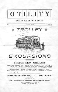 |
This is the outer cover of what claims to be Volume 1, Number 1 for April 1903 of a periodical named Utility Magazine. The magazine consists of four pages, one sheet of paper, and the only content is advertising. All except the back page is about the sightseeing excursions available for a fifty cent fare Daily and Sunday from Canal and Camp Streets, leaving at 10:30 a.m. Making a thirty mile trip through the French and American quarters, viewing over one hundred points of local and historic interest. Returning at 1:30 p.m. Gentleman in charge of car delivers an interesting lecture during trip. The two interior pages give the major points of interest on the route. The car started on Canal at Camp/Chartres, then turned down N. Peters Street to Esplanade Avenue. It proceeded out Esplanade all the way to City Park Avenue, and turned up toward the cemeteries at the head of Canal Street. It then followed the West End line out to its terminal at the lake, and returned via Canal Street to Camp Street. The car turned up Camp Street and proceeded through the Garden District to Audubon Park, apparently following the Prytania line in both directions. The trip ended on return to Canal Street. The picture shown on the cover of the magazine is not a true picture of a New Orleans streetcar. The sightseeing car seen in Pictures 101 to 103 might have been offering the service described here. New Orleans-Crescent Information and Employment Bureau |
| Picture 105. | |
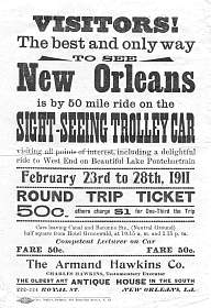 |
This handbill advertised a sightseeing streetcar service, probably an expansion of the service described in Picture 104 from once to twice daily, and from thirty to fifty miles. (But the fare remained at 50 cents!) The handbill mentions that the service departs from the neutral ground at Canal and Baronne, presumably from the center track. One assumes that, in addition to visiting West End, it toured several of the major lines in the city. The West End line was about a 13 mile round trip. The entire streetcar system at this time included about 200 route miles, so the sightseeing car apparently traversed about a quarter of the city system. However, we don't have a detailed route, as we do for the 1903 service described in Picture 104. The significance of the dates February 23 to 28, 1911 is not known. It is also unclear whether the Armand Hawkins Co., advertised at the bottom of the handbill, had anything to do with the sightseeing service; one suspects that they simply bought advertising space on the handbill. |
| Picture 106. | |
 |
This picture is looking out toward the lake from about Camp/Chartres Streets. The first building to our right is May's Drug Store. The two closest streetcars are both Palace cars. The open platforms on the cars date the picture to before 1904. The car at our left, coming toward us on the riverbound inner track, is car 036, signed for the Dauphine line. To our right from car 036, heading away from us on the lakebound inner track, is car 085, signed for the Magazine line. At least three more cars can be seen to the right, two in front of car 085 on the inner track, and one on the lakebound outer track. In the foreground, we see again the double right rail on the outer track. Note the fashionably dressed ladies with their wonderful chapeaux! Albertype Co./Thomas F. Cessner |
| Pictures 107-109, 109.5, 110-112. | |
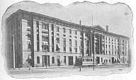 |
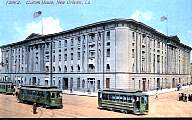
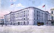
The Custom House, on Canal between Decatur and N. Peters.
The top picture illustrated a New Orleans City RR tourist guide and system map
dated February 1902. The streetcar could be on the French Market, Levee &
Barracks, S. Peters, or Tchoupitoulas* lines of NOCRR.
The next picture was taken some time between 1905 and 1909.
At this time, New Orleans Railway and Light Co. operated all streetcar service
in New Orleans. The nearest car is so labeled; the green car behind
it appears to be marked for one of the component companies leased by NOR&L.
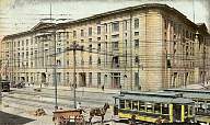
The third picture probably dates from
about the same time as the second. At the left, single truck Ford,
Bacon & Davis (FB&D) car 188, identifiable by the wide clerestory roof, is
approaching on the outer riverbound track. On the right, Canal Belt
Palace car 017 is following single truck car 163 lakebound on the inner track.
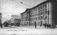
The fourth picture, postmarked 1909 and probably taken a year or more earlier,
features FB&D cars on the outer tracks; the cars on the inner tracks are
probably Brills. The fifth picture is probably a few years
newer than the previous ones, because there is a Pay Conductor on Entering
(PAYE) sign on the dash of Palace car 02, just left of center, and the
other two cars in the view. However, an artist's airbrush has removed
not only the overhead wires and poles, but even the trolley pole of the
single truck car just right of center.
In the sixth picture, a French Market or Levee & Barracks car has just turned
into N. Peters from Canal, heading downtown (away from the camera). Notice
that no tracks cross Canal Street at this point.
The bottom picture, postmarked 1915, features two cars on N. Peters Street.
The nearer one is crossing Canal from S. Peters, going away from the camera;
on its return trip, it will cross into Tchoupitoulas* Street.
This car is on the Tchoupitoulas line, which for a few years in the 'teens crossed
Canal and ran down N. Peters from here.
Note the flags drawn above the roof of the building in several of these views.
Grombach-Faisans Co., Ltd. (second), Rotograph Co. (third), I. Stern (fourth),
Acmegraph Co. (fifth), Detroit Publishing Co. (sixth), S. H. Kress & Co. (bottom)
*Pronounced chop-i-too-lus. |
 |
|
 |
|
 |
|
 |
|
 |
|
 |
|
| Picture 113. | |
 |
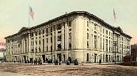
Three streetcars pass in front of the Custom House. Note that the car at the far right, which is on the outer lakebound track, is painted in a different scheme than the other two. Raphael Tuck & Sons |
| Picture 114. | |
 |
A streetcar on the French Market or Levee and Barracks line turns from N. Peters Street into Canal Street, with the Custom House in the background. The Brill Co. built 201 of these little 7- and 8-window cars between 1893 and 1895 to begin electric service over many of the former horsecar lines of the New Orleans Traction Co. The picture clearly shows that this short car had double trucks. These were the Brill 22-E Maximum Traction trucks, much advertised by the Brill Co. at that time. But these trucks were prone to derail in New Orleans, and were quickly replaced by single trucks. So this picture probably dates from before 1900. Frank S. Thayer |
| Pictures 115 and 115.5. | |
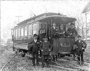 |
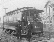
Here are closeup views of one of the 7-window 1894 Brill cars, like that seen in Picture 114. These pictures appear to date from the period 1894 to 1899, because the car is lettered N. O. C. & L. R. R., i.e., New Orleans City & Lake Railroad. This company, formed from the old New Orleans City RR in 1883, was from 1892 to 1899 one of the component companies of the New Orleans Traction Co. Car 115 is still riding on its original Brill 22-E Maximum Traction trucks. This is probably the original as built appearance of these cars. The location is not known, but the tracks suggest that it is at a car barn, perhaps Canal Barn or Esplanade Barn. Close inspection of the front clerestory reveals the route name Esplanade, which would have been housed at one of those car barns. On the back of the top picture, in contemporary handwriting, are the names of the men, in this order: Conductor Jackson, I. M. Kellogg, I. W. Ford, John Jacquet, ______ Thomas, J. L. Paine, and R. O'Brian [sic]. The back of the bottom picture lists, in the same handwriting, the names R. O'Brian [sic], J. L. Paine, and I. W. Ford. However, there is no specific indication of which person is which, except for the conductor (presumably the motorman, since no conductor is in sight). The September 1928 issue of Electric Traction published a copy of the second picture, and the caption identifies the man at the far left of that phoro as Robert Bob O'Brien, who came up through the ranks to become in 1914 superintendent of equipment. Matching faces between the two pictures leads to the conclusion that the names listed are given in order, left to right (regardless of how high they are standing), except for conductor Jackson. |
 | |
| Picture 116. | |
 |
This view of Canal Street looks across toward the downtown side, probably around 1904. Amazingly enough, the nearest car appears to be the same Brill no. 115 as in the previous pictures, a little later in its life. Vestibule windows were added to all New Orleans streetcars around 1904, when the Louisiana legislature mandated closed vestibules. That appears to be the only major difference between this view of car 115 and the previous ones. It is still running on its Brill Maximum Traction trucks. It is operating riverbound on the inside track. Unfortunately, the route sign on the dash cannot be read. |
| Pictures 117 and 118. | |
 |
These two pictures, taken from similar vantage points, both date from the early 1900s. The upper view is probably the earlier one: although it has a 1907 date and postmark, it appears to predate the 1904 state law that required vestibules. The view is out, from a vantage point at about Camp Street. The closest car is single truck number 231, whose route sign (hanging from the front platform roof) identifies it as being on the Jackson Avenue line. It is inbound (riverbound) on the outer track, heading for the loop. Cars 230-244 were FB&D cars, built in 1900 by the St. Louis Car Co. We see signs for several businesses on the downtown side of Canal Street, including the Marx Bros. Clothiers, Union Central Life, and at 615 and 617 Canal, M. Scooler Jeweler. The lower picture is probably from just a few years later, perhaps about 1907. This view looks out from the middle of the block between Camp/Chartres and St. Charles/Royal, toward Royal Street. Single truck car 219 in green is approaching on the outer track, operating on the Tulane Belt line. This car is another in the FB&D group 160-229, built by American Car Co. in 1899. One can almost, but not quite, read the company names on the side of the red and yellow cars on the far side of the neutral ground. The sign for B. Cohn Co., seen in the lower view painted on the brick at the top of a building, seems in the upper view to have been covered by a temporary banner advertising Grunewald's Music Store. At the left in the distance in both pictures, we can see the dome of the old Maison Blanche building. C. B. Mason (lower) |
 |
|
| Picture 119. | |
 |
This view is looking out toward the lake from Carondelet and Bourbon Streets. The red and yellow car nearest the photographer is marked N. O. & C. R. R. Co., and is on the outer riverbound track. Raphael Tuck & Sons |
| Picture 120. | |
 |
This January 1918 view of Canal Street looks toward the downtown side and in toward the river from Carondelet Street. In the background we see B. Cohn Co. and the Marks Isaacs Company, advertising Millinery, Ladies Ready To Wear, etc. Prominent in the center of the picture is a single truck deck roof streetcar on the outer riverbound track. Ahead of it is an arch roof streetcar, which would have to be one of the 400-449 series double truck cars, probably on either the Tulane or the St. Charles belt line, heading for the loop at the foot of Canal. |
| Picture 121. | |
 |
This stereoptican view, probably taken around 1905, looks out toward the old Maison Blanche building, with the St. Charles/Royal intersection in the foreground. We see several prominent signs advertising businesses: on the uptown side of Canal (to the left), M. B. Stevens & Co. Outfitters; on the downtown side, B. Cohn Co. and Grunewald's Music (twice!). We can clearly see the tracks crossing Canal at St. Charles/Royal and at the next intersection, Carondelet/Bourbon. And we see the empty space where there is no center track between Baronne/Dauphine and St. Charles/Royal. Just the other side of the Baronne/Dauphine intersection, there are streetcars on the center track, presumably cars of a West End train at its terminus. Berry, Kelley & Chadwick |
| Picture 122. | |
 |
A Knights of Pythias convention was held in New Orleans in 1906. We see some of the knights in uniform at the left, under the sign for Moses & Son. The view looks out, toward the lake. The next cross street, where we see a streetcar crossing Canal Street, is Carondelet/Bourbon, and the streetcar is on the Clio or Carondelet line. On our right on the outer riverbound track, car 51 is signed both on its dash and in its clerestory window for the Broad line of the old Orleans RR. In 1902, the Orleans RR had ordered twelve cars of the FB&D design, numbered 50-61, from the St. Louis Car Co. These were unusual among FB&D cars in having arched rather than rectangular windows. They were equipped with couplers for pulling trailers, as can be seen in this picture. The side of the car is lettered N. O. RYS. CO. After passing the next cross street, St. Charles Street, the car will switch to its center track terminus. Note the patriotic bunting on many buildings, presumably for the Pythian convention. Wright Photo |
| Pictures 123, 124, and 125. | |
 |
These three pictures are looking out toward the lake. The building with the small tower and pole is at Baronne Street. In the top picture, which is from 1904, the closest car is single-truck FB&D car 206, lakebound on the outer track on the St. Charles Belt line. Beyond it, a Palace car is riverbound on the inner track. In the middle picture, two Palace cars operate on the inner tracks. Here is another view of the ornate scroll work on the poles supporting the overhead system and the street lights. The bottom picture features Palace car 014 heading out on the inner lakebound track. The Robertson Palace cars were built by the St. Louis Car Co. in 1902, and operated until 1935. Originally numbered 01-045 and 058-0137, they were renumbered 600-723 in 1918 (omitting 075, which had been wrecked). Rotograph Co. (top), C. B. Mason (middle), Raphael Tuck & Sons (bottom) |
 |
|
 |
|
| Pictures 125.5 and 125.6. | |
 |
Here is a view down the middle of Canal Street, looking lakeward from about St. Charles and Royal Streets. (The second picture is a closeup taken from the first.) The nearest streetcar is Palace car 612, so the photo must date at least from 1918, when the Palace cars were renumbered into the 600s and 700s; it probably dates from the early to mid 1920s. A few other streetcars can be glimpsed in the background. Notice the deteriorated condition of the pavement and the track. |
 |
|
When the West End steam line was electrified, its terminus on the middle of three pairs of tracks between Carondelet/Bourbon and St. Charles/Royal was removed, and a new single center track was built from about Claiborne to Baronne/Dauphine. Thereafter, West End trainspowered now by double truck electric passenger cars instead of steam locomotivesterminated at Baronne/Dauphine. (After this, there were five tracks from Claiborne to Peters, except that there were only four tracks in the two blocks between Baronne/Dauphine and St. Charles/Royal.) In 1911, yet another new terminus for the trains of the West End line and the new Spanish Fort line was built on S. Rampart just off Canal; the center track on Canal between Rampart and Baronne/Dauphine was thereafter not used in revenue service.
| Picture 126. | |
 |
A view from Rampart Street out toward the lake, about 1922. The curves into S. Rampart (to the left in the picture) carried West End and Spanish Fort trains to and from their terminus in the block of S. Rampart just above Canal. Note the traffic policeman's stand blocking the out-of-service center track. The car on N. Rampart is on the Canal Belt or Dauphine line. The cars on the inner Canal Street tracks are on the Canal/Esplanade Belts or on the Villere line; the outer tracks here belong to the (North) Claiborne line. E. C. Kropp Co. |
| Picture 127. | |
 |
This view looks out Canal toward Carondelet/Bourbon. We see here part of the two block gap in the center track. Notice that passengers boarded and alighted from the left side of cars on the inner tracks. This practice ended after the inner tracks were moved closer together, eliminating the center track, in the 1929 rebuilding. The car crossing the center is turning left from the lakebound inner track uptown into Carondelet, on the Coliseum, Henry Clay, or Annunciation line. C. B. Mason |
| Pictures 128 and 129. | |
 |
Two similar views of Canal Street, looking toward the lake. In each picture, the first cross street is Carondelet/Bourbon, where in the upper picture we see cars on both the inner and outer lakebound tracks taking on passengers. The rightmost car in each picture (on the outer lakebound track) is one of the first group of arch roof streetcars in New Orleans, other than some home-built trailers. Cars 400-449 were built in 1915 by the Southern Car Co. of High Point, NC. They were typically used on the St. Charles and Tulane Belt lines. The cars of the later 800-972 class and 1000-1019 class were refined versions of the 400-449 class. In the lower picture, car 405 appears to be signed for the Tulane Belt line. The car next to it, on the inner lakebound track, is a Palace car. C. B. Mason (lower) |
 |
|
| Picture 130. | |
 |
A Brill semiconvertible car clears Carondelet Street riverbound on the outer track. Note the Herr fender folded up behind the rear platform; this type of fender was used for a while on New Orleans streetcars. This picture looks toward the downtown side of Canal Street from Carondelet. For other views of this type of car, see Pictures 136 and 194. The building at the left edge of the picture is the one which, seen from the other direction, carries a painted sign near the top that reads B. Cohn Co. in ornate script; see, for example, Pictures 117 and 194. |
Incidentally, consolidation of companies during the 1890s reduced the number of systems to four, then in 1902 to one, although complete corporate merger was not accomplished until 1925. This made possible routing and trackage improvements without the necessity of considering which companies owned which tracks or which franchises.
About 1904, wide gauge double track was laid from the old outer-track loop at the Liberty Monument to a new stub terminus close to the river at the ferry landing. This was served at first by the wide-gauge Dryades line, necessitating the installation of a third rail for double gauge on the outer Canal Street tracks from St. Charles/Royal to the loop. In 1911, the two blocks of outer track on the downtown side of Canal between Dauphine and Rampart were also double gauged, completing the double gauge on the outer tracks between Rampart and the Liberty Monument. Operation of the ferry terminus was assumed by the Louisiana line in 1917, then by a new Ferry line in 1923. The Ferry line was discontinued and the ferry terminus was abandoned in 1925.
Further extensive changes in the termini at the Liberty Monument took place around 1906. A second, inner loop was installed around the monument, and the inner stub terminus was removed. (The stub terminus in Wells Street remained, however, until some time around 1915.) The number of tracks on Canal remained eight. The outer and inner riverbound tracks each led into one of the loops. On the other side, each loop divided into three layover tracks, which extended almost to Peters, where they converged to become the outer and inner lakebound tracks. (The center, fifth track extended out from Peters only.) This undoubtedly improved the operation of the inner terminus considerably, since looping large numbers of cars is faster than changing ends.
Click here to view a map of Canal Street trackage in 1907.
| Picture 131. | |
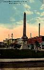 |
The Liberty Monument, erected in 1891 at the foot of Canal Street. Notice the shelter and the numerous cars on various layover tracks in the eight track section. J. Scordill |
| Picture 131.3. | |
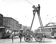 |
The terminal area at the foot of Canal Street, some time between 1899 and 1904. Emergency tower wagon no. 2 of the New Orleans City R. R. Co. is supporting two men working on some problem with the overhead wire, as the motorman and conductor of car 510 look on from the platforms of their car. The 510 is one of the American Car Co. double truck cars built to Barney & Smith design in 1898. It was usually assigned to pull a train of trailers on the West End Line, but that line did not usually come to the foot of Canal, so the car may be in use as a single streetcar. At left on the outer track is FB&D car 207, one of the standard gauge cars 160-229 built by American in 1899 for the New Orleans & Carrollton. Of the three other single truck cars in view, the one to the right is one of the Esplanade cars, numbers 260-277, built in 1900 by St. Louis Car Co., and the other two are 20' Brills built between 1893 and 1895 for New Orleans City R. R. Teunisson Photo, collection of Eugene Groves |
| Picture 131.6. | |
 |
Standard gauge car 230 on the outer track, and wide gauge car 240 on the inner track, approach the termini at the foot of Canal Street, about 1900-1904. The view looks out, away from the river, with the Custom House at the right. A track crosses from S. Peters St. at the left, curving into the inner lakebound track at the right; car 230 is just crossing that track. The switches in the foreground connect the layover tracks for the inner-track lines, which are behind the photographer, converging to the inner lakebound track. FB&D car 230 is one of the 230-244 series built in 1900 by St. Louis Car Co. for the New Orleans & Carrollton. Car 240 is one of the 240-259 group built by Jackson & Sharp in 1899 for New Orleans Traction Co. (The distortion at the lower left corner of the photo is a tear in the emulsion on the glass plate. We have chosen not to attempt a repair.) |
| Picture 132. | |
 |
A picture of the eight track layover area at the foot of Canal Street, from a stereoptican card, after the 1906 rearrangement of these tracks. The photographer is facing out (toward the lake), with the Liberty Monument behind him. The cars on the far left track are coming toward the camera, so they are on the inner riverbound track, approaching the inner loop. The next three tracks (from left to right) are the three layover tracks for the inner track system. The two rightmost tracks seen here are two of the three layover tracks for the outer track system; the third layover track would be farther to the right, and is apparently unoccupied at this moment. The track across the foreground of the picture is probably the track leading to the Wells Street crossover. At the far right of the picture, we can see a switchman wielding his iron bar to change a track switch. Behind him can be seen the track leading back to Canal from the Wells Street crossover. There are two small buildings on the neutral ground, at the far right of the picture, which presumably were shelters for the carmen and other street railway personnel working here. Davis Bros. |
| Picture 133. | |
 |
The double loop at the Liberty Monument, some time between the addition of the second loop in 1906 and about 1920 (judging by the absence of automobiles). At the left, a streetcar is just starting around one of the loops. According to Hennick and Charlton, the second loop was added around 1906, and the ferry terminus was added about 1904. However, there is no sign of the track to the ferry terminus in this picture. It may be out of sight at the edges of the view. Or perhaps the second loop was built before the ferry terminus, and these approximate dates need to be adjusted. The track in the foreground belongs to a steam railroad, and has no connection to the streetcar tracks (except for a crossing with the ferry terminus track, which is not seen here). This same steam railroad track can also be observed in pictures from a half century later (e.g., Picture 335). Collection of the New Orleans Public Library, courtesy of Edward Branley |
| Picture 133.4, 133.5, and 133.6. | |
 |
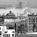
This is one of a group of pictures taken by the Detroit
Publishing Co. photographer from the heights of the Hotel Grunewald.
Together, they show a panoramic view of New Orleans. This one of the
set shows Canal Street at the left, with the Custom House prominent at the
left edge of the photo. We can see the Mississippi River across the back,
and Algiers, the far shore, faintly in the distance. The dome in the
right foreground is the Jesuit Church of the Immaculate Conception on Baronne
Street.
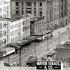
The other two pictures are high-resolution details from the original, as posted to the web by Shorpy.com. The first, with the Mayer Israel sign in the foreground on the roof of a near building, shows three single truck cars moving along Canal Street. The two at the left are heading lakebound, and the one by itself is on a riverbound track. They are in the block of Canal between Chartres/Camp (out of the picture at the left) and Decatur/Magazine. The Custom House, on Canal between Decatur and N. Peters, is in the background of this closeup. Unfortunately, no details of the streetcars are visible. The second closeup is perhaps the best part of this picture. We see the L&N depot at the left center, and the ferry building to its right (with a clock tower), then a steamboat with its twin smoke stacks. Two streetcars are visible. One is near the L&N depot on one of the loops, preparing to return out Canal Street; it appears to be crossing Canal Street. The other is at the ferry landing. This is one of only two pictures known to the author that show a streetcar at the ferry landing (see the next picture for the other one). The car is on the Dryades-Ferry line, which served this terminal from its inception in 1901 until about 1917, when the Louisiana line took over service to the landing. Library of Congress, Prints and Photographs Division, Detroit Publishing Company Collection. Detail views from Shorpy.com |
 |
|
 |
|
| Picture 134. | |
 |
This is the only other picture known to the author that shows the ferry stub at the foot of Canal Street, below the Liberty Monument loops. It is looking out, away from the river. We can see, directly ahead and just left of center, a straight view out Common Street (Tulane Avenue). In the left distance, one can make out the tower of the Hibernia Bank Building, which was completed in 1921. Judging by the light automobile traffic, the picture was probably taken not much later than that year. There is a single truck streetcar at the terminus, serving either the Louisiana line (if the picture is before 1923) or the Ferry line (if 1923 or later). Behind this car, we can see a long, arch roof car, one of the Southern Car Co. 400s, or just possibly an 800 series car, making its way around the outer loop at the Liberty Monument. There are very few streetcars in the scene, suggesting perhaps that it is Sunday. |
| Pictures 135 and 135.5. | |
 |
Looking up Camp Street from Canal Street, between 1900 and 1904, as Palace car 078 on the Prytania line waits to enter Canal Street. The lower picture is a detail made from the upper by Shorpy.com. Library of Congress, Prints and Photographs Division, Detroit Publishing Company Collection; closeup from Shorpy.com |
 |
|
| Picture 136. | |
 |
A view up St. Charles Street from Canal. Note the upbound track crossing Canal, used by the old St. Charles Street RR Carondelet and Clio lines. Car 306 has just come down St. Charles on the Coliseum or Henry Clay line, and is turning in on Canal. This double truck car is a Brill semiconvertible, one of 25 delivered in 1906 as numbers 300-324. They were renumbered 450-474 in 1917, and retired in 1935. One car, 453, was saved as a training car, and was eventually restored and put on display. Acmegraph Co. |
| Pictures 137 through 141. | |
 |
One lantern slide view and four postcard views
up St. Charles Street, with the photographer
standing at Canal looking toward the new St. Charles Hotel. The first
view is seen in both formats, a lantern slide from the firm of Unger & Hoffmann
in Dresden, Germany, and a postcard postmarked 1908 from the Detroit Photographic
Co. It shows a downbound Coliseum or Henry Clay car approaching Canal
Street. The second view gives us a good look at the ornate ironwork on the
building at the right. In the third view, a double-truck car, probably a Brill
semiconvertible on the Coliseum line, is downbound toward Canal Street.
The bottom picture, dated 1904, shows how well the wheel gauge of a typical New
Orleans wagon matched the 5' 2½" gauge of the streetcar track.
It is often said that the odd measure of standard track gauge, 4' 8½", was
dictated by the wheel gauge of horse-drawn wagons, but this picture shows that
in New Orleans, with predominantly a wider streetcar gauge of 5' 2½", wagons were
built to that gauge. It was undoubtedly a smoother ride when a teamster could
put his wagon in the grooves of the rails, but it drove streetcar motormen mad!
Lantern slide by Unger & Hoffmann (Series XXVIII, No. 1); postcards by
Detroit Photographic Co. (top), C. T. American Art (second),
Hugh C. Leighton Co. (third), Rotograph Co. (bottom)
This was the third St. Charles Hotel to occupy this site. Its two predecessors each burned down. This building was erected in 1896, and served until it was demolished in 1974. |
 |
|
 |
|
 |
|
 |
|
| Pictures 141.4, 141.5, and 141.6. | |
 |
One more view up St. Charles Street from Canal. The top picture is the postcard from the Detroit Publishing Co., and the second is the original photo from which the postcard was made, taken from the publisher's archive. We see an upbound car as it leaves Canal on one of the former St. Charles Street RR lines: Clio, Carondelet, or Dryades. Note the early form of automotive competition at the right, with a sign saying For Hire. The third picture is a detail from the second, showing a surprisingly clear view of the streetcar and another automobile. Car 74 was one of the group of FB&D cars numbered 51-80, purchased by the St. Charles Street RR from St. Louis Car Co. in October 1901, order number 232. It originally had an open vestibule; the closed vestibule seen here dates the photo to no earlier than 1904, when all open vestibules were enclosed in accord with Louisiana law. The route sign on the dash it is not readable, but the one in the clerestory end window identifies the car as being on the Clio line. The larger dash sign reads Pay Conductor on Entering, which suggests a date closer to 1910. Detroit Publishing Co. (postcard); Library of Congress, Prints and Photographs Division, Detroit Publishing Company Collection (second and third pictures) |
 |
|
 |
|
| Picture 142. | |
 |
This is a view of St. Charles Street just up from the St. Charles Hotel, looking up, about 1901. Single truck car 285 at our left is downbound, on the Coliseum or Henry Clay line. Cars 278-288 were built by Brill in 1895. To our right, car 40 is upbound on the Dryades line. The route sign on the roof of the front platform reads Dryades St., and another sign atop the clerestory roof reads Canal St. Car 40 is the high number from the first order of electric streetcars for the St. Charles Street RR. Six-window cars 1-40 were ordered from the Pullman Co. in 1895. Ahead of car 40, we can see a horse-drawn wagon using the streetcar tracks, and another streetcar ahead of the wagon. M. H. Zahner |
| Picture 143. | |
 |
Single truck FB&D Clio car 299 is heading upbound (away from Canal Street) on St. Charles Street, as we look back toward Canal, c. 1915. Cars 290-299 were part of the next-to-last order of FB&D cars for New Orleans, being built in 1906 by American Car Co. On the right, another FB&D car serving the Henry Clay line heads downtown (toward Canal). Charles L. Franck |
| Picture 144. | |
 |
Double truck Brill semi-convertible car 300 is heading down St. Charles Street on the Coliseum line as a two-horse team passes. An FB&D single truck car is approaching upbound from Canal Street on the Clio, Carondelet, or Dryades line. Behind car 300, this view, postmarked 1914, features the then-new Whitney Bank Building. New Orleans News |
| Pictures 145, 146, and 146.5. | |
 |
Two versions of the same picture, looking up Carondelet from Canal. Henry Clay car 255 has just taken the curve in the foreground from the inner lakebound track to head up Carondelet. Cars 240-259 were built by Jackson & Sharp in 1899. The upper picture is the published postcard; the middle is the photo from which it was made, taken from the publisher's archive; and the bottom picture is a detail from the middle picture, made by Shorpy.com. Detroit Publishing Co. (upper); Library of Congress, Prints and Photographs Division, Detroit Publishing Company Collection (middle); closeup from Shorpy.com |
 |
|
 |
|
| Picture 147. | |
 |
A Palace car on the Canal Street inner track, and single truck FB&D car 247 on the outer track, are both proceeding toward the river (right to left) in this view up Carondelet Street. A Coliseum, Henry Clay, or Annunciation car is operating up Carondelet (away from the photographer). In the distance, a Clio or Carondelet car is approaching Canal Street (toward the photographer). In the left foreground we can see the track which that car will take to cross Canal Street and proceed to the downtown portion of its route. The umbrella in the foreground shades the traffic policeman's stand, but the policeman is elsewhere at the moment. Behind the Palace car, in the building with the distinctive corner tower, is Fellman's store selling Dry Goods and Fancy Goods. Down Carondelet Street can be seen a City Bank sign. This postcard is captioned The Wall Street of New Orleans. Carondelet Street is the location of various important banking and financial institutions, some of which built tall buildings such as the ones seen in the background here. S. H. Kress & Co., collection of Joseph Skinner |
| Picture 148. | |
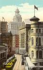 |
Two streetcars pause for passengers on the downbound track on Carondelet Street. We are looking from Canal Street into the financial district that grew up along Carondelet. The Cotton Exchange is one of these buildings, and we can see a sign for the Marine Bank. C. B. Mason |
| Picture 149. | |
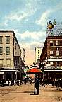 |
This view is looking down Royal Street into the Vieux Carré from Canal. St. Charles Street is behind the photographer. The traffic policeman, with his primitive traffic signal and an umbrella for shade from the sun, is standing where the center, fifth track would be if it passed here; this is the end of the gap in the center track. Only a few streetcar lines crossed Canal, notably the Clio and Carondelet lines of the old St. Charles Street RR. This was their upbound crossing. Note the jog in the track as it crosses Canal Street. C. T. American Art. |
| Picture 150. | |
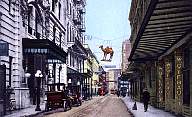 |
A Clio or Carondelet car has just passed some early automobile competition in this view up Royal Street looking toward Canal from about a block and a half away. The view today is not much different, except that the streetcars are gone, the cars are modern, and the camel has vanished from its perch over the street. Detroit Publishing Co. |
| Pictures 150.5 and 150.6. | |
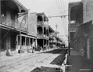 |
Another view of Royal Street, looking away from Canal Street, with a Clio car coming toward the photographer. The second picture is a detail closeup from the first. The car is signed Clio St. above the platform hood, with a secondary Bourbon St. sign on top of the clerestory roof. It's easy to see why this car line was sometimes called the C-L-ten line. Car 4 was one of the first group of electric cars, numbers 1-40, ordered from the Pullman Co. in 1895 by the St. Charles Street RR. The picture dates to before 1905, since in 1904, all car platforms were enclosed. We see some of the ornate ironwork on the balconies of the buildings. Library of Congress, Prints and Photographs Division, Detroit Publishing Company Collection |
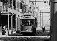 |
|
| Picture 151. | |
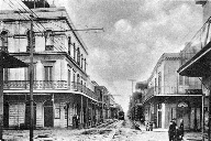 |
A Clio or Carondelet car on Royal Street heading uptown toward Canal Street. The children at the right are giving the photographer a nice clear view of the street, and in return are getting a good look at the mysterious things he is doing to take the picture. The absence of vehicles other than the streetcar, and the small number of pedestrians, are striking to anyone familiar with Royal Street today. Notice the lacy ironwork on the balconies of several buildings, typical of the Vieux Carré. Albertype |
| Picture 151.5. | |
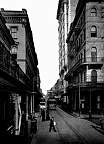 |
A St. Charles Street RR car, number 65 (or maybe 66), rolls up Royal Street toward Canal. The picture comes from a Southern Pacific RR travel brochure for the 1912-13 season, so it was probably taken around 1910 to 1912. St. Charles Street RR cars 51-80 were Ford Bacon & Davis (FB&D) cars, built by the St. Louis Car Co. in 1901. They carried their original numbers even after consolidation of the streetcar companies, until renumbered in the 300s in 1918. Southern Pacific RR. |
| Pictures 152 through 156. | |
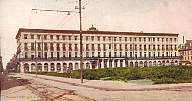 |
These pictures show the grand Hotel Royal. It opened in 1835 as the Exchange Hotel, and later was known as the St. Louis Hotel. The large and beautiful building stretched all the way from Royal to Chartres Street. A new street, Exchange Alley, was cut through to Canal Street between Royal and Chartres to lead to the front door of the hotel. During the reconstruction period, the building was leased to the State of Louisiana, serving as the state capitol beginning in 1874. In 1882, after repair of considerable damage, it was once again opened as a hotel. It was again in run down condition as early as 1903, and by 1912 was being used as a stable. After further damage in the storm of September 30, 1915, it was demolished. The top two views show the entire front of the building, about 1907, with Royal Street at the left. The block in front of the hotel had been cleared to make way for a new Civil District Courts Building, which was constructed beginning in 1908. The middle picture appears to have been taken during construction of the courts building. A track can be seen in the left foreground, on the construction site, presumably built to move materials around the site. The next view shows the hotel after construction of the courts building; shadows of parts of the completed courts building can be seen on the hotel. The bottom view, from a glass slide, features an approaching Clio streetcar, on its way to cross Canal Street and return to its uptown neighborhoods. In the middle and the two bottom pictures, note how the columns of the increasingly decrepit hotel building have been partially hidden by sign boards. At the right in the bottom picture, we glimpse a corner of the completed Civil District Courts Building, which by then occupied the block in front of the hotel (see Picture 157). The identity of the gentleman with the straw boater is, unfortunately, not known. C. B. Mason (top), Curt Teich (second), Lipsher Specialty Co. (middle), Acmegraph (fourth) |
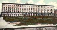 |
|
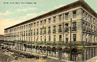 |
|
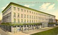 |
|
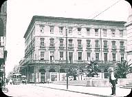 |
|
| Picture 157. | |
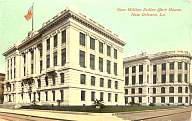 |
The Civil District Courts Building, glimpsed in Pictures 155 and 156. Royal Street is at the left, showing a bit of streetcar track. J. Scordill |
| Picture 158. | |
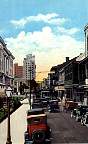 |
An upbound car heading toward Canal Street through the Vieux Carré (the French Quarter) on Royal Street. We can see the sign atop the Hotel Monteleone. The building in the left foreground is the Civil District Court Building. Note the ornamental lacework for which the Vieux Carré is justly famous. The overhead system, as in most of New Orleans, is supported by steel poles with bracket arms. |
| Pictures 159 through 162. | |
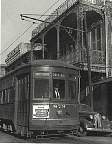 |
Cars of the Perley Thomas/Brill 800-900 class make their way through the Vieux Carré. The car in the upper picture, Brill-built car 879, is heading for Desire Street. The second picture shows another Brill car, number 825, some time in 1942. The third picture shows another car of this class, framed by the ornamental iron work for which the Vieux Carré is well known. The bottom picture features car 832 on the Desire line in the early 1940s, dressed in a patriotic livery to advertise the sale of War Bonds during World War II. For many years, these cars were the mainstay of the all the lines traversing the Quarter, including the Desire, Gentilly, and City Park lines along Royal and Bourbon Streets. (The preserved car 453, from the Brill semi-convertible class, was never used on the Desire line, although it is often displayed with a Desire route sign.) Giant Card Co. (third picture) |
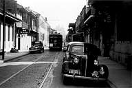 |
|
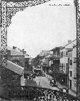 |
|
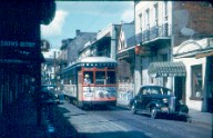 |
|
| Picture 163. | |
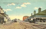 |
This view of the French Market, at the point where Decatur Street and N. Peters Street come together, shows the sad condition of much of the street paving in New Orleans, and suggests why teamsters liked to drive their wagons along the streetcar tracks (see Picture 141). We are in the Vieux Carré, looking down toward Esplanade Ave., along Decatur St. (left) and N. Peters St. (right). The streets are paved with ballast block, but the drainage and maintenance are obviously poor. Note the wooden crosswalks for pedestrians. The track at the left is the inner terminal of the French Market line of the Orleans RR; it was later called French Market - City Park, and still later simply City Park. From its origins as a horsecar line in 1870 until 1910, it had the nearly unique feature of not going to Canal Street. As can be seen here, even though it passed within about 15 feet of the Levee & Barracks line of the New Orleans City RR (the tracks at the right, on N. Peters St.), there was originally no track connection between them. Later, in 1910, the City Park line was connected to the track on N. Peters, and ran up to Canal Street. Acmegraph |
| Picture 164. | |
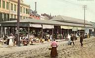 |
Another view of N. Peters Street, just down from the previous picture. Note the uneven ballast block paving. The lady crossing the street in the center is wearing the skirt and blouse of a typical French Creole or Cajun housewife. Detroit Publishing Co. |
| Picture 165. | |
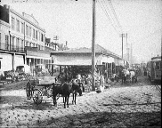 |
Two streetcars on the French Market or Levee & Barracks lines pass the busy stalls of the French Market on N. Peters St. one early morning around 1906. Note that this French Market line, originated by the New Orleans City RR, is different from the French Market - City Park line of the Orleans RR, mentioned above in Picture 163. Library of Congress, Prints and Photographs Division, Detroit Publishing Company Collection |
| Picture 166. | |
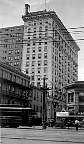 |
Single truck car 44 is serving the Dryades line, heading toward the river on the outer track as it passes University Place, which becomes Dryades Street (now called O'Keefe) one block away. The photographer is looking uptown across Canal Street toward the Grunewald Hotel. The St. Charles Street RR ordered cars 41-50 in 1899 from the St. Louis Car Co. |
| Picture 167. | |
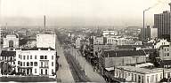 |
This is Rampart Street, the outer boundary of the Vieux Carré, looking downtown from about Common Street (Tulane Avenue), around 1909. Canal Street is the nearest cross street. The closest block is South Rampart; North Rampart is on the other side of Canal. A Dryades or St. Charles Belt car on dual-gauge track is about to turn from S. Rampart onto Canal. At the left can be seen the Southern Railway depot on Canal Street. At this time, the West End terminus on S. Rampart had not yet been built, and West End trains still terminated on the center track of Canal. Library of Congress, Prints and Photographs Division, Panoramic Photographs Collection. |
| Pictures 168 and 169. | |
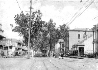 |
Here is Esplanade Ave., the downriver boundary of the Vieux Carré. The upper view looks from N. Rampart Street toward the river; the lower, postmarked 1903, looks away from the river from N. Peters past the old Mint (at the left). Esplanade was a little bit narrow to have the typical double track in its neutral ground. As a result, the devil strip the space between the two tracks was more narrow on Esplanade than on most New Orleans streets. Note that the trolley wires are suspended between poles set at the edges of the neutral ground, rather than from a center pole, as is the usual neutral ground practice in New Orleans. But still, space was found for a double line of trees. New Orleans Curio Co./Albertype (upper), A. Selige (lower) |
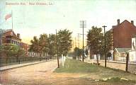 |
|
Text, captions, photos by R. Hill, and photos by the author,
© 1999, 2000, 2001, 2002, 2003, 2004, 2005, 2006, 2007, 2008, 2009, 2010,
2011, 2012, 2013, 2014, 2015, 2016, 2020, 2021, 2022, 2023 H. George Friedman, Jr.
All rights reserved. Permission is hereby given for the QUOTATION of
SHORT excerpts, as long as credit is given to H. George Friedman, Jr.
Computer Science Department, University of Illinois at Urbana-Champaign, Home Page